FACT Buildings Footprint and Height
ML detected building footprints and height open database. Bing Maps open building footprints. with partial global coverage, only US and Europe included here. https://github.com/microsoft/GlobalMLBuildingFootprints
Use
- Pull the image:
docker pull registry.git.nilu.no/fact/data/fact_bldgs:latest
- Run this data service:
docker run -t -i --name fact_bldgs -e MARIADB_DATABASE=FACT_bldgs -e MYSQL_ROOT_PASSWORD=devops -p 3315:3306 -d registry.git.nilu.no/fact/data/fact_bldgs:0.1
The container makes available a MariaDB instance with the full database on airports and traffic FACT_bldgs. It is reachable on port 3315 of the localhost and the root password is 'devops'.
Specifications
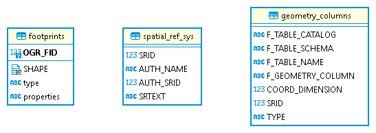
Table           |Size (MB)|Rows (#) |
----------------+---------+---------+
footprints      | 91081.03|341191944|
geometry_columns|     0.02|        0|
spatial_ref_sys |     0.02|        0|
Properties in footprints contain a dictionary with height (-1 if missing) and confidence, example:
{ "height": -1.0, "confidence": -1.0 }
All spatial objects are converted to EPSG:4326.
Notes
The code downloads files for European countries and US, transforms them into geojson with right CRS, and then loads them into a DB.
Not used here: https://sites.research.google/open-buildings/
Author
Riccardo Boero - ribo@nilu.no
License
The data and software in this repository are licensed under theOpen Data Commons Open Database License (ODbL) v1.0
Citation
- Boero, Riccardo. 2024. “FACT Data: Buildings Footprint and Height.” OSF. doi:10.17605/OSF.IO/CHDJR.
Part of the Fine scAle eConomic daTa - FACT project:
- Boero, Riccardo. 2024. “Fine scAle eConomic daTa - FACT.” OSF. doi:10.17605/OSF.IO/PV4ZW.
